La visita al molino de Regolgo nos permite comprender cómo se obtenía la harina hace más de un siglo, antes de que llegara la electricidad. El edificio fue construido en 1799 y dejó de funcionar a finales de la década de los setenta.
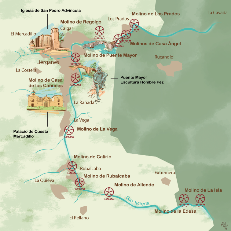
Junto con el molino de Regolgo, existían otros 11 molinos en las proximidades del curso medio del río Miera, siendo el más conocido el del Centro de Interpretación del hombre pez. Esto nos da una idea de la importancia de la actividad agrícola para la población. El sistema de molino hidráulico se compone de un conjunto de elementos que pueden parecer primitivos, pero forman parte de un sistema de aprovechamiento de la fuerza hidráulica ingenioso y sofisticado que resultaba vital para la subsistencia de los campesinos de los alrededores, que se dedicaban en su mayoría al cultivo de cereales.
The visit to the Regolgo mill allows us to understand how flour was obtained over a century ago, before the discovery of electricity. The building was constructed in 1799 and ceased operations in the late 1970s.
In addition to the Regolgo mill, there were 11 more mills in the immediate vicinity of the middle course of the Miera River, with the Fishman Interpretation Center being the most well-known. This fact gives us an idea of how important agricultural activity was for the local population.
The hydraulic mill system is made up of a set of elements that may seem primitive but form part of an ingenious and sophisticated system for harnessing hydraulic power, which was vital for the subsistence of the surrounding farmers, who were mostly dedicated to the cereal cultivation.
MOLINOS DE LIÉRGANES
Hoy en día, en Liérganes y Los Prados, se encuentran restos y vestigios de 12 molinos en un tramo del río Miera de aproximadamente 7 km, con un estado de conservación muy diferente entre ellos.
En 1493, Colón transportó maíz a España desde América, y su cultivo se extendió rápidamente a Galicia, Asturias y Cantabria hacia finales del siglo XVII. En poco tiempo, ya ocupaba todo el norte de España y el resto de la península.
El maíz, junto con las alubias, las patatas, los tomates y los pimientos, revolucionaron la alimentación de la mayoría de la población europea. Los hábitos cambiaron y la población de Cantabria aumentó.
Durante los siglos XVII y XVIII, su cultivo se generalizó de forma intensiva y desplazó al mijo y al centeno como base de la alimentación.
Ilustración 1, Detalle de una panoja.
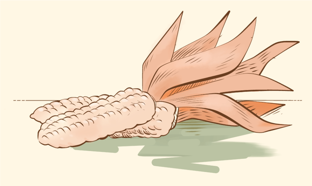
Así, el maíz fue el origen y la razón de la proliferación de los molinos hidráulicos en la cornisa cantábrica. No existen datos fiables sobre la cantidad total de molinos que pudo haber en Cantabria, pero se puede estimar que su número podría haber estado alrededor de 2.000.
En el territorio de Liérganes, que en esa época estaba compuesto por los pueblos de Liérganes, Pámanes y Los Prados, se han documentado 21 molinos.
Es curiosa la inscripción que se encuentra en el dintel de entrada a la huerta de los molinos de Casa Ángel, y dice así:»
A GLORIA Y HONRA DE DIOS, QUE PUSO MEDIDA Y TASA ESTAMOS GANANDO DOS PARA EL DUEÑO DE ESTA CASA
LIÉRGANES MILLS
Nowadays, in Liérganes and Los Prados, there are remains and vestiges of 12 mills in a stretch of the Miera River of approximately 7 km, with their state of conservation varying widely.
In 1493, Columbus transported corn to Spain from America, and its cultivation quickly spread to Galicia, Asturias, and Cantabria toward the end of the 17th century. In a short period of time, it already occupied the entire north of Spain and the rest of the peninsula.
Corn, along with beans, potatoes, tomatoes, and peppers, revolutionized the diet of most of the European population. Habits changed, and the population in Cantabria increased.
During the 17th and 18th centuries, its cultivation became intensively widespread and displaced millet and rye as the basis of the diet.
Thus, corn was the origin and reason for the proliferation of hydraulic mills on the Cantabrian coast. Data on the total number of mills that could have existed in Cantabria is not reliable, but there could have been about 2,000 of them.
Twenty-one mills are documented in the Liérganes area, which at the time was formed by the villages of Liérganes, Pámanes, and Los Prados.
The existing inscription on the entrance lintel to the orchard of the Casa Ángel mills draws the visitor’s attention and reads like this:
TO THE GLORY AND HONOR OF GOD WHO SET MEASURE AND RATE,
WE ARE WINNING TWO FOR THE OWNER OF THIS HOUSE
Mapa 1:Ubicación de los molinos en el curso medio del Río Miera.
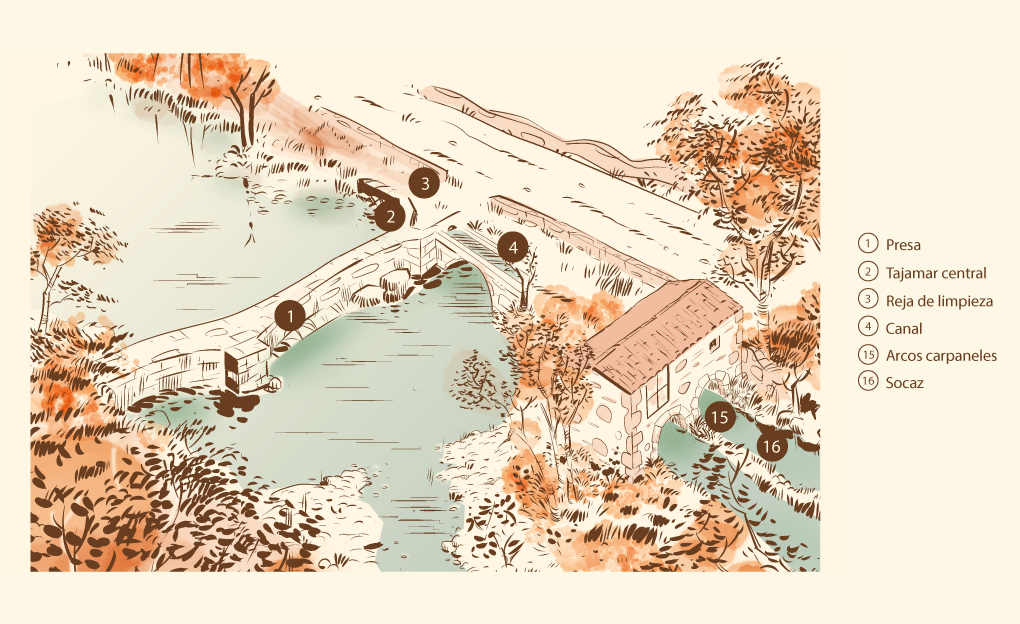
Los molinos harineros de agua, como el molino de Regolgo situado junto al río Miera, aprovechaban la fuerza de la corriente mediante un canal que hacía que el agua se precipitase en caída libre.
Constaba de una presa (1), un tajamar central (2) y estaba dotado de una compuerta y una reja (3) de limpieza siguiendo un canal (4) de sillares labrados de 44 metros de longitud que conducía a una cámara de carga, con rejas de limpieza en las tomas y un aliviadero que se encontraba en el interior del edificio del molino.
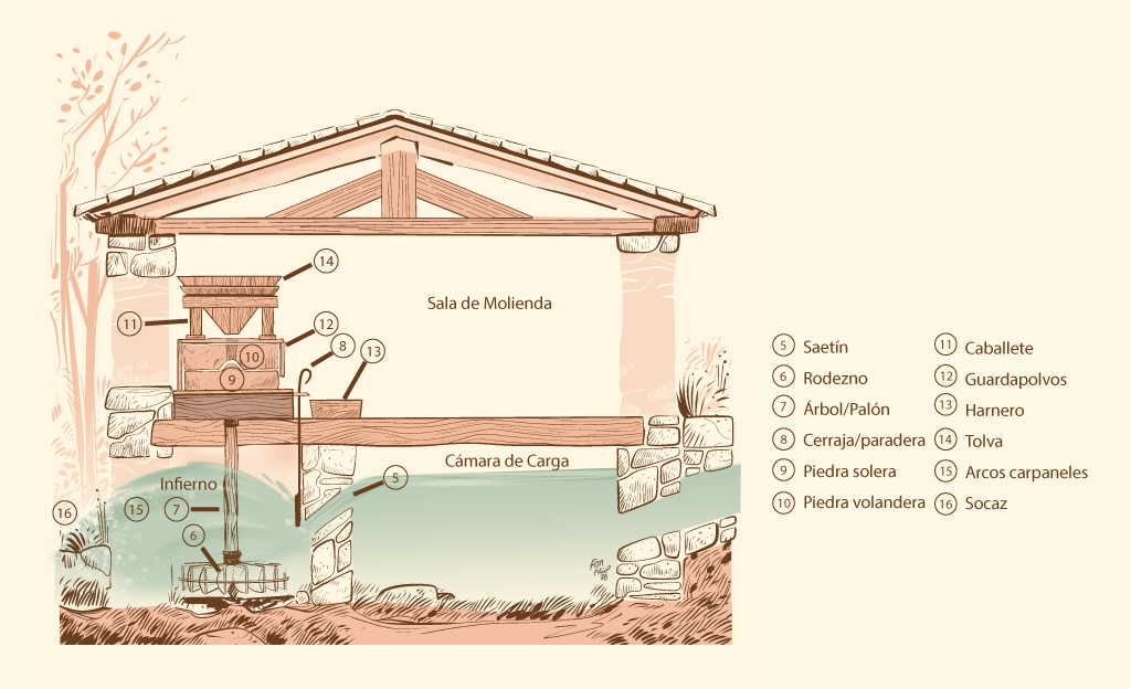
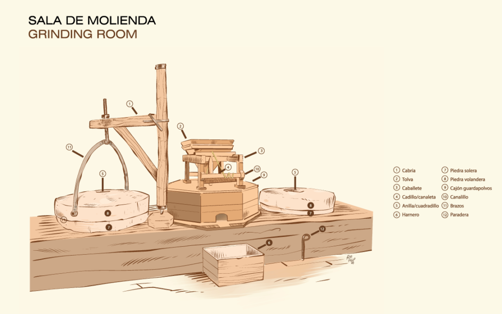
Al final de la caída, el agua pasaba por estrechos conductos reforzados llamados “saetines” (5) que impulsaban el chorro de agua a alta presión contra el rodezno (6) ruedas que tenía en todo su diámetro externo tenían una serie de cucharas denominadas “álabes”, que transmitían el movimiento directamente desde el eje vertical “palón” (7) a un aparejo donde se colocaba un juego de piedras de moler. La piedra inferior, solera (8), era fija y la superior, volandera (9), móvil, reguladas ambas mediante palancas llamadas “cabrios” (llamadas así en referencia al estratega griego Cabrias) o “medialuna”. Había un rodezno (6) por cada juego de piedras de moler y, cuando el agua pasaba por éste, atravesaba los arcos carpaneles (15) y regresaba al cauce por un canal de retorno “socaz” (16).
Water flour mills, such as the Regolgo´s mill located next to the Miera River, took advantage of the force of the current thanks to a channel that caused the water to precipitate in free fall.
It consisted of a dam (1), a central cutwater (2) and was equipped with a gate (3) and a cleaning grate following a 44-meter-long channel (4) made of carved ashlars that led into a loading chamber, with cleaning grates in the intakes and a spillway that was inside the mill building.
At the end of the fall, the water passed through narrow reinforced conduits called “saetines” (5) that propelled the jet of water at high pressure against horizontal wheels (6), that had a series of “spoons” called “álabes” along their entire external diameter, transmitting the movement directly from the vertical axis “palón” (7) to a rig where a set of grinding stones was placed. The lower stone, “solera” (8), was fixed, and the upper one, “volandera” (9), was mobile, both being regulated through levers called “cabrios” (named after the Greek military tactician Cabria) or “medialuna”. There was a “rodezno” (6) for each set of grinding stones and, when the water passed through this, it crossed the carpanel arches (15) and returned to the main channel “socaz” (16).